
Daegu地形图
点击地图以显示海拔。
关于这张地图
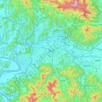
名称:Daegu地形图、海拔、地势。
地点:Daegu, 41939, South Korea (35.71130 128.44180 36.03130 128.76180)
平均海拔:213 米
最低海拔:5 米
最高海拔:1,176 米
其他地形图
点击地图以查看其地形、其海拔和其地势。
Jeju Island
The climate of the highlands in the middle of the island where Hallasan is located is quite different from that of the rest of the island. As the altitude increases, the average temperature decreases and the climate becomes colder. The highlands of Jeju Island have the highest annual precipitation in Korea.
平均海拔:98 米
Seoraksan National Park
The reserve has an area of 163.6 square kilometres (63.2 sq mi) and includes many mountain peaks measuring over 1,200 metres above sea level, the tallest being Daecheongbong, at an altitude of 1,708 metres (5,604 ft). The ranges are composed largely of dissected granite and gneiss. The annual precipitation is…
平均海拔:611 米
Yongsan-gu
Yongsan is located next to the Han River, with level ground in the west of the district which has been used for transportation (rail) and commercial use since the early 20th century. To the east and north in the land is steeper and rises towards Namsan which lies to the north. Namsan has an elevation of 243m…
平均海拔:39 米
Anyang-si
The main river is Anyang River (one of the four main tributaries of the Han River in Seoul), which is 32.2 km (20.0 mi) long. It has a basin area of 275 km2 (106 sq mi), fed by 21 tributaries. The center of the overall elliptical basin topography is low and flat. The river runs through the center of Anyang and…
平均海拔:126 米
Jeju Island
The climate of the highlands in the middle of the island where Hallasan is located is quite different from that of the rest of the island. As the altitude increases, the average temperature decreases and the climate becomes colder. The highlands of Jeju Island have the highest annual precipitation in Korea.
平均海拔:98 米
Pyeongtaek-si
With its low average elevation, Pyeongtaek has the warmest January average temperature in Gyeonggi Province at -4.5°C and the hottest average temperature in August at 26.4°C. The annual average precipitation is 1,100 millimeters with an average of 283.4 millimeters in July and 207.3 millimeters in August,…
平均海拔:59 米
South Chungcheong
At 845 metres, Mount Gyeryong is the most notable elevation. It is located in a national park which is noted for its unique rock features. Apart from the stone formations there are a number of old temples. These include Gwanchok-sa, a temple which is home to the largest stone Buddha in Korea. In 1978 the Taean…
平均海拔:89 米
Jeju
The island is home to 660,000 people, but hosts 15,000,000 visitors per year. English is not widely spoken in Jeju, and as a matter of fact, "the local dialect is different enough from Korean that it is recognized as a distinct language." "Until recently, Chinese travelers accounted for 80% of foreign…
平均海拔:28 米
Daejeon
In 1973, Buk-myeon and Yuseong-myeon of Daedeok-gun were each elevated to Sintanjin-eup and Yuseong-eup, respectively. In 1977, the ward system (gu-je) was implemented in Daejeon, establishing two wards: Jung-gu and Dong-gu. In 1983, Daejeon further expanded by incorporating the entire areas of Yuseong-eup and…
平均海拔:160 米
Suwon-si
Since 2013, Suwon has been home to the professional baseball team KT Wiz. The team played at Sungkyunkwan University until Suwon Baseball Stadium remodeling was completed in time for their elevation to the KBO League in 2015. The stadium was previously the home of the Hyundai Unicorns, who folded after the…
平均海拔:88 米