
Mount Atago地形图
点击地图以显示海拔。
关于这张地图
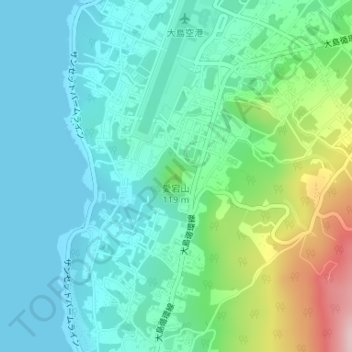
名称:Mount Atago地形图、海拔、地势。
地点:Mount Atago, Tokyo, Japan (34.77053 139.35975 34.77063 139.35985)
平均海拔:60 米
最低海拔:0 米
最高海拔:248 米
其他地形图
点击地图以查看其地形、其海拔和其地势。
Miyakejima
The island is a stratovolcano with a granitic composite cone, dating from the late Pleistocene period, between 10,000 and 2,000 years ago. The island has a roughly circular coastline, 88.3 kilometers in length, with an average diameter of eight kilometers. The highest elevation Mount Oyama (雄山, Oyama-san)…
平均海拔:168 米