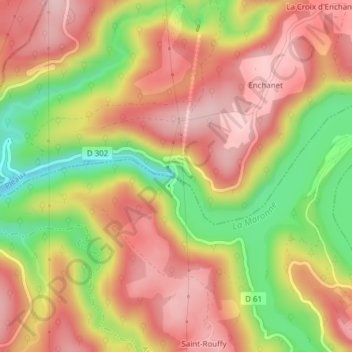
点击地图以显示海拔。
名称:Barrage d'Enchanet地形图、海拔、地势。
地点:Barrage d'Enchanet, Pleaux, Mauriac, Cantal, Auvergne-Rhône-Alpes, France métropolitaine, 15700, France (45.08078 2.19371 45.08243 2.19463)
平均海拔:498 米
最低海拔:370 米
最高海拔:586 米
点击地图以查看其地形、其海拔和其地势。
France > Auvergne-Rhône-Alpes > Cantal > Pleaux
平均海拔:578 米
平均海拔:598 米
平均海拔:679 米
平均海拔:582 米
平均海拔:554 米
平均海拔:519 米