
Le Barthelemy地形图
点击地图以显示海拔。
关于这张地图
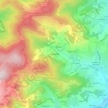
名称:Le Barthelemy地形图、海拔、地势。
平均海拔:585 米
最低海拔:332 米
最高海拔:880 米
其他地形图
点击地图以查看其地形、其海拔和其地势。
Vaugneray
France > Auvergne-Rhône-Alpes > Rhône > Vaugneray
Enfin, on notera utilement les références topographique à la commune dans le fichier topographique de Marguerite Gonon.
平均海拔:448 米