
Kadiri地形图
点击地图以显示海拔。
Kadiri
Kadiri is located at 78.170 degrees E longitude and 14.120 degrees N latitude and has an average elevation of 504.00 meters (1653 feet) above MSL. Kadiri is surrounded by hill on the north and east.
关于这张地图
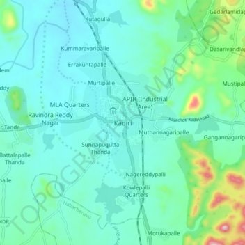
名称:Kadiri地形图、海拔、地势。
地点:Kadiri, Sri Sathya Sai, Andhra Pradesh, 515591, India (14.06823 78.12107 14.14823 78.20107)
平均海拔:550 米
最低海拔:487 米
最高海拔:850 米