Eastanollee地形图
点击地图以显示海拔。
关于这张地图
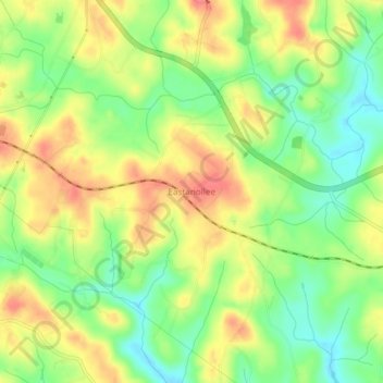
名称:Eastanollee地形图、海拔、地势。
地点:Eastanollee, Stephens County, Georgia, 30538, United States (34.50027 -83.27549 34.54027 -83.23549)
平均海拔:266 米
最低海拔:231 米
最高海拔:302 米
其他地形图
点击地图以查看其地形、其海拔和其地势。

点击地图以显示海拔。
名称:Eastanollee地形图、海拔、地势。
地点:Eastanollee, Stephens County, Georgia, 30538, United States (34.50027 -83.27549 34.54027 -83.23549)
平均海拔:266 米
最低海拔:231 米
最高海拔:302 米
点击地图以查看其地形、其海拔和其地势。