
Sugarland地形图
点击地图以显示海拔。
关于这张地图
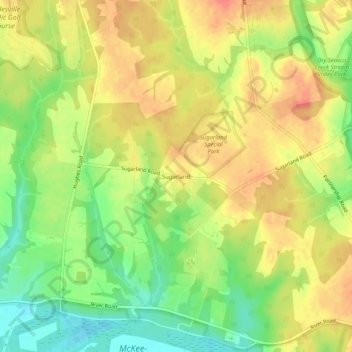
名称:Sugarland地形图、海拔、地势。
地点:Sugarland, Montgomery County, Maryland, 20837, United States (39.07955 -77.41110 39.11955 -77.37110)
平均海拔:85 米
最低海拔:56 米
最高海拔:108 米
其他地形图
点击地图以查看其地形、其海拔和其地势。
Damascus
United States > Maryland > Montgomery County > Damascus
As an unincorporated area, Damascus' boundaries are not officially defined. Damascus is recognized by the United States Census Bureau as a census-designated place, and by the United States Geological Survey as a populated place located. Damascus proper is a locally high spot at 847 ft (258m) above sea level,…
平均海拔:195 米
Damascus
United States > Maryland > Montgomery County > Damascus
As an unincorporated area, Damascus' boundaries are not officially defined. Damascus is recognized by the United States Census Bureau as a census-designated place, and by the United States Geological Survey as a populated place located at 39°16′16″N 77°12′22″W / 39.27111°N 77.20611°W /…
平均海拔:195 米
Cabin John
United States > Maryland > Montgomery County > Cabin John
Historically, Cabin John has been part of the region known as the Potomac Gorge (Potomac Palisades), an approximately 15-mile-long (24 km) corridor or "fall zone" that sees a transition between the hard bedrock of the Piedmont to the softer rocks and soils of the Atlantic Coastal Plain and representing a drop…
平均海拔:48 米
North Potomac
United States > Maryland > Montgomery County > North Potomac
Between the 1990 and 2000 census, North Potomac gained and lost land. The loss was caused when a portion of the North Potomac territory, plus Potomac territory, was used to create the Travilah census designated place. According to the United States Census Bureau, North Potomac has a total area of 6.6 square…
平均海拔:116 米
Travilah
United States > Maryland > Montgomery County > Travilah
The United States Geological Survey lists six features in Montgomery County with Travilah in all or part of their name. The Travilah Census Designated Place has an ID of 2390400 and an elevation of 233 feet. It has a latitude of 390325N and a longitude of 0771445W—a location of 39°3′25″N…
平均海拔:96 米