
Monte Catillo地形图
点击地图以显示海拔。
关于这张地图
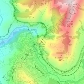
名称:Monte Catillo地形图、海拔、地势。
地点:Monte Catillo, Tivoli, Roma Capitale, Lazio, 00019, Italy (41.96493 12.80557 41.96503 12.80567)
平均海拔:284 米
最低海拔:54 米
最高海拔:588 米
其他地形图
点击地图以查看其地形、其海拔和其地势。
Villa d'Este
Italy > Lazio > Roma Capitale > Tivoli
Tivoli had been a popular summer residence since ancient Roman times due to its altitude, cooler temperatures and its proximity to the Villa Hadriana, the summer residence of the Emperor Hadrian I. The position of Governor of Tivoli came with an official residence located in a former convent of the Benedictine…
平均海拔:203 米