
Marshall地形图
点击地图以显示海拔。
关于这张地图
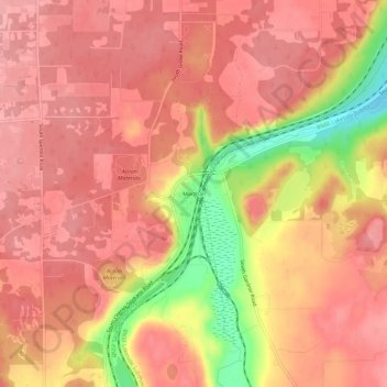
名称:Marshall地形图、海拔、地势。
地点:Marshall, Spokane County, Washington, 99020, United States (47.54460 -117.51542 47.58460 -117.47542)
平均海拔:697 米
最低海拔:619 米
最高海拔:725 米
其他地形图
点击地图以查看其地形、其海拔和其地势。
Millwood
United States > Washington > Spokane County
The topography of the city is mostly flat as it lies on the floor of the Spokane Valley, though it does slope gently down towards the north. The northern edge of town is defined by the Spokane River, where the terrain promptly drops about 20 feet down to the river bank.
平均海拔:600 米
Riverside State Park
United States > Washington > Spokane County > Spokane
Terrain in park is varied, with steep valleys along the rivers and more flat plateaus above. The Spokane River falls from approximately 1,680 feet when it enters the park in the south to approximately 1,540 feet at the Long Lake Reservoir on the northern edge of the park. Surrounding plateaus rise to 2,200…
平均海拔:645 米