
Afing - Avigna地形图
点击地图以显示海拔。
关于这张地图
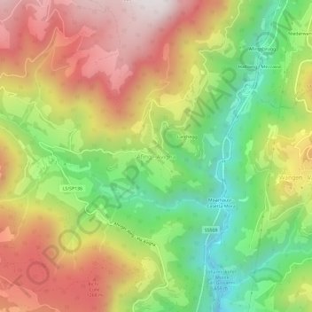
名称:Afing - Avigna地形图、海拔、地势。
平均海拔:955 米
最低海拔:430 米
最高海拔:1,515 米
其他地形图
点击地图以查看其地形、其海拔和其地势。
Ritten - Renon
Italy > Trentino – Alto Adige/Südtirol > South Tyrol
The 111-square-kilometre (43 sq mi) community is named after the high plateau, elevation 1,100 to 1,400 metres (3,600 to 4,600 ft), the Ritten or the Renon, on which most of the villages are located. The plateau forms the southeast tip of the Sarntal Alps mountain range and is located between, and on average…
平均海拔:1,123 米
Seiser Alm-Gruppe - Gruppo Mont de Sëuc - Gruppo dell'Alpe di Siusi
Italy > Trentino – Alto Adige/Südtirol > South Tyrol > Kastelruth - Castelrotto
Seiser Alm (Italian: Alpe di Siusi, Ladin: Mont Sëuc) is a Dolomite plateau and the largest high-elevation Alpine meadow (German: Alm) in Europe. Located in Italy's South Tyrol province in the Dolomites mountain range, it is a major tourist attraction, notably for skiing and hiking.
平均海拔:1,466 米
Hafling - Avelengo
Italy > Trentino – Alto Adige/Südtirol > South Tyrol
The emblem is a natural breed Haflinger horse on a mountain with three vert peaks, through a pine tree. The mountain and the pine symbolize that the village is located at high elevation. The coat of arms was granted in 1967.
平均海拔:1,228 米