Namoroc地形图
点击地图以显示海拔。
关于这张地图
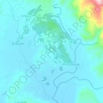
名称:Namoroc地形图、海拔、地势。
地点:Namoroc, Ilocos Norte, Ilocos Region, 2915, Philippines (18.19128 120.69531 18.23128 120.73531)
平均海拔:75 米
最低海拔:36 米
最高海拔:379 米
其他地形图
点击地图以查看其地形、其海拔和其地势。

点击地图以显示海拔。
名称:Namoroc地形图、海拔、地势。
地点:Namoroc, Ilocos Norte, Ilocos Region, 2915, Philippines (18.19128 120.69531 18.23128 120.73531)
平均海拔:75 米
最低海拔:36 米
最高海拔:379 米
点击地图以查看其地形、其海拔和其地势。