
Khumjung地形图
点击地图以显示海拔。
Khumjung
Khumjung (Nepali: खुम्जुंग) is a village in Khumbu Pasanglhamu rural municipality of Solukhumbu District in Province No. 1 of north-eastern Nepal. It is located in the Khumbu subregion inside Sagarmatha National Park, a world heritage site. The village is at an elevation of 3,790 metres above sea level, and is situated near Mount Khumbila.
关于这张地图
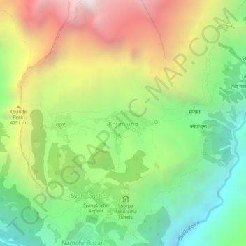
名称:Khumjung地形图、海拔、地势。
平均海拔:3,888 米
最低海拔:2,946 米
最高海拔:5,231 米
其他地形图
点击地图以查看其地形、其海拔和其地势。