
Montana-Village地形图
点击地图以显示海拔。
关于这张地图
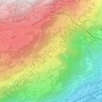
名称:Montana-Village地形图、海拔、地势。
平均海拔:1,125 米
最低海拔:512 米
最高海拔:1,709 米
其他地形图
点击地图以查看其地形、其海拔和其地势。
Mollens (VS)
Switzerland > Wallis > Sierre > Crans-Montana
The former municipality is located in the Sierre district, on the right bank of the Rhone river. The municipality stretches from an elevation of 900 to 3,177 m (2,953 to 10,423 ft). It consists of the villages of Mollens and Cordona, the scattered settlements of Conzor, Laques and Saint-Maurice-de-Laques as…
平均海拔:1,996 米
Randogne
Switzerland > Wallis > Sierre > Crans-Montana
The former municipality is located in the Sierre district, on the northern slope of the Rhone valley. The municipality goes from the Rhone valley at an elevation of 540 m (1,770 ft) to Mont Bonvin at 2,995 m (9,826 ft). It consists of the village of Randogne (which was rebuilt in stone after the destructive…
平均海拔:1,614 米
Montana
Switzerland > Wallis > Sierre > Crans-Montana
The former municipality is located in the Sierre district, above the right bank of the Rhone. It consists of the villages of Montana and Corin, part of the Champzabé, the hamlet of Diogne as well as the resort of Montana-Vermala (located at an elevation of 1,500 m (4,900 ft) and shared between Montana and…
平均海拔:1,231 米