Moigrad-Porolissum地形图
点击地图以显示海拔。
关于这张地图
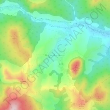
名称:Moigrad-Porolissum地形图、海拔、地势。
地点:Moigrad-Porolissum, Mirșid, Sălaj, 457252, Romania (47.17702 23.12387 47.21702 23.16387)
平均海拔:366 米
最低海拔:242 米
最高海拔:575 米
其他地形图
点击地图以查看其地形、其海拔和其地势。

点击地图以显示海拔。
名称:Moigrad-Porolissum地形图、海拔、地势。
地点:Moigrad-Porolissum, Mirșid, Sălaj, 457252, Romania (47.17702 23.12387 47.21702 23.16387)
平均海拔:366 米
最低海拔:242 米
最高海拔:575 米
点击地图以查看其地形、其海拔和其地势。