
Goode地形图
点击地图以显示海拔。
关于这张地图
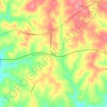
名称:Goode地形图、海拔、地势。
地点:Goode, Bedford County, Virginia, 24556, United States (37.33875 -79.41170 37.37875 -79.37170)
平均海拔:253 米
最低海拔:199 米
最高海拔:293 米
其他地形图
点击地图以查看其地形、其海拔和其地势。
Blue Ridge Mountains
United States > Virginia > Bedford County
Although the term "Blue Ridge" is sometimes applied exclusively to the eastern edge or front range of the Appalachian Mountains, the geological definition of the Blue Ridge province extends westward to the Ridge and Valley area, encompassing the Great Smoky Mountains, the Great Balsams, the Roans, the Blacks,…
平均海拔:548 米