
Bastion地形图
点击地图以显示海拔。
关于这张地图
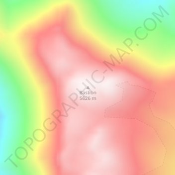
名称:Bastion地形图、海拔、地势。
地点:Bastion, Iglesia, San Juan, Argentina (-30.20164 -69.76480 -30.20154 -69.76470)
平均海拔:5,308 米
最低海拔:4,780 米
最高海拔:5,623 米
其他地形图
点击地图以查看其地形、其海拔和其地势。
Ischigualasto Provincial Park
Most of the park lies within the Valle Fértil Department, with a minor part in the Jachal Department of San Juan, at an altitude of about 1,300 m (4,300 ft) amsl. The park is part of the western border of the Central Sierras, and features typical desert vegetation (bushes, cacti and some trees) which covers…
平均海拔:1,258 米
Calingasta
Calingasta has a rugged, mountainous topography due to its location at the foot of the Andes. Mount Mercedario is the eighth-highest mountain of the Andes with an altitude of 6,720 metres (22,050 ft). It is located 100 kilometres (62 mi) north of Aconcagua. The precordillera range is the Sierra del Tontal,…
平均海拔:2,393 米
Ischigualasto Provincial Park
Most of the park lies within the Valle Fértil Department, with a minor part in the Jachal Department of San Juan, at an altitude of about 1,300 m (4,300 ft) amsl. The park is part of the western border of the Central Sierras, and it features typical desert vegetation (bushes, cacti and some trees) which…
平均海拔:1,258 米