
Branderwood地形图
点击地图以显示海拔。
关于这张地图
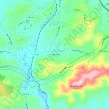
名称:Branderwood地形图、海拔、地势。
地点:Branderwood, Roanoke County, Virginia, 24018, United States (37.18153 -80.00865 37.22153 -79.96865)
平均海拔:405 米
最低海拔:326 米
最高海拔:587 米
其他地形图
点击地图以查看其地形、其海拔和其地势。
Vinton
United States > Virginia > Roanoke County
Vinton has varied topography, considering its 3.2 square mile size. The above-mentioned lake is at an elevation of 890 feet (270 m) above sea level. The Vinton side of the lake consists of a steep, wooded cliff 150 feet (46 m) in vertical height. Vinton's highest point is on Olney Road, at an elevation of…
平均海拔:304 米