
Mapleton Falls地形图
点击地图以显示海拔。
关于这张地图
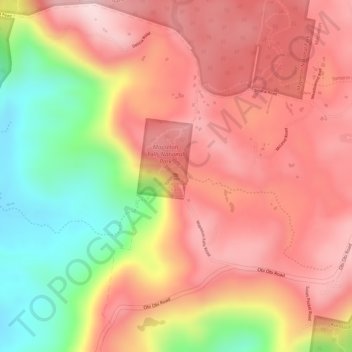
名称:Mapleton Falls地形图、海拔、地势。
平均海拔:330 米
最低海拔:144 米
最高海拔:440 米
其他地形图
点击地图以查看其地形、其海拔和其地势。
Minyama
Australia > Queensland > Sunshine Coast Regional
Minyama is located within the Kawana Waters urban centre. Situated on the Mooloolah River, the suburb is almost entirely surrounded by water, and artificially constructed harbours and waterways dominate the topography. The suburb's main thoroughfare, Nicklin Way, is the location of several large retail…
平均海拔:3 米