
Handies Peak地形图
点击地图以显示海拔。
关于这张地图
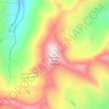
名称:Handies Peak地形图、海拔、地势。
地点:Handies Peak, Hinsdale County, Colorado, United States (37.91294 -107.50450 37.91304 -107.50440)
平均海拔:3,887 米
最低海拔:3,481 米
最高海拔:4,265 米
其他地形图
点击地图以查看其地形、其海拔和其地势。
Lake City
United States > Colorado > Hinsdale County
Lake City experiences a continental climate (Köppen climate classification Dfb) that only just escapes being classified as semi-arid due to its relatively wet early springs and late autumns. On average, the wettest month is August, and the driest is February. Very large daily temperature swings are a regular…
平均海拔:2,834 米
Weminuche Wilderness
United States > Colorado > Hinsdale County
The Weminuche Wilderness is a wilderness area in southwest Colorado managed by the United States Forest Service as part of the San Juan National Forest on the west side of the Continental Divide and the Rio Grande National Forest on the east side of the divide. The Weminuche Wilderness was designated by…
平均海拔:3,059 米
Lake City
United States > Colorado > Hinsdale County
Lake City experiences a continental climate (Köppen climate classification Dfb) that only just escapes being classified as semi-arid due to its relatively wet early springs and late autumns. On average, the wettest month is August, and the driest is February. Very large daily temperature swings are a regular…
平均海拔:2,834 米
Lake San Cristobal
United States > Colorado > Hinsdale County
Lake San Cristobal is a lake in the U.S. state of Colorado. Located in the San Juan Mountains at an elevation of 9,003 feet (2,744 m), the freshwater lake is 2.1 miles (3.4 km) long, up to 89 feet (27 m) deep, has a surface area of 0.52 square miles (1.3 km2), and holds about 11,000 acre-feet (14,000,000 m3)…
平均海拔:2,947 米