
Palmerston North地形图
点击地图以显示海拔。
Palmerston North
Although the land Palmerston North is situated on is bounded by the lofty Ruahine and Tararua ranges in the east and south respectively, the city has a predominantly flat appearance. The occasional rise in elevation occurs further away from the river and is especially pronounced in the north and northeast, and also on the south side of the river. The typical urban area elevation ranges between 20 and 40 metres (65–130 ft) above sea level.
关于这张地图
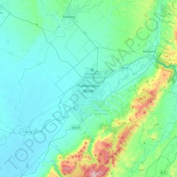
名称:Palmerston North地形图、海拔、地势。
平均海拔:118 米
最低海拔:3 米
最高海拔:753 米