
Unionville地形图
点击地图以显示海拔。
关于这张地图
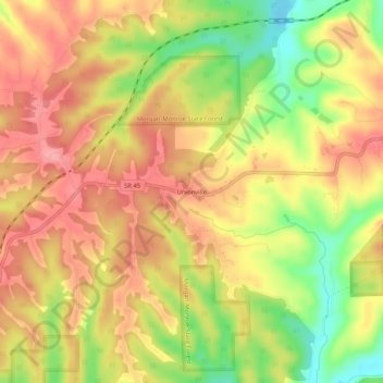
名称:Unionville地形图、海拔、地势。
地点:Unionville, Monroe County, Indiana, 47468, United States (39.21005 -86.43611 39.25005 -86.39611)
平均海拔:241 米
最低海拔:183 米
最高海拔:279 米
其他地形图
点击地图以查看其地形、其海拔和其地势。
Bloomington
United States > Indiana > Monroe County
Bloomington is an area of irregular limestone terrain characterized by sinks, ravines, fissures, underground streams, sinking streams, springs and caves. It is in the rolling hills of southern Indiana, resting on the intersection of the Norman Uplands and the Mitchell Plain. The city's relatively varied…
平均海拔:241 米
Bloomington
United States > Indiana > Monroe County
Bloomington is an area of irregular limestone terrain characterized by sinks, ravines, fissures, underground streams, sinking streams, springs and caves. It is in the rolling hills of south Central Indiana, resting on the intersection of the Norman Upland and the Mitchell Plain. The city's relatively varied…
平均海拔:241 米
Lake Monroe
United States > Indiana > Monroe County
Lake Monroe is a reservoir located about 10 miles (16 km) southeast of Bloomington, Indiana, United States. The lake is the largest entirely situated in Indiana with 10,750 acres (43.5 km2) of water surface area spread over the counties of Monroe and Brown. Capacity varies from 292 gigalitres (237,000…
平均海拔:205 米