
Hoye-Crest地形图
点击地图以显示海拔。
Hoye-Crest
Hoye-Crest is a summit along Backbone Mountain just inside of Garrett County, Maryland. It is the highest natural point in Maryland at an elevation of 3,360 feet (1,020 m).
关于这张地图
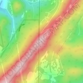
名称:Hoye-Crest地形图、海拔、地势。
地点:Hoye-Crest, Garrett County, Maryland, 26716, United States (39.23748 -79.48542 39.23758 -79.48532)
平均海拔:887 米
最低海拔:743 米
最高海拔:1,022 米
其他地形图
点击地图以查看其地形、其海拔和其地势。
Oakland
United States > Maryland > Garrett County
Oakland, owing to its high elevation and valley location, is among the coldest and snowiest locales in the state of Maryland, and has a warm-summer humid continental climate (Köppen Dfb). The state record low of −40 °F or −40 °C was recorded here on January 13, 1912. The monthly mean temperature ranges…
平均海拔:763 米