
Batticaloa地形图
点击地图以显示海拔。
Batticaloa
Batticaloa is in the eastern coast of Sri Lanka on a flat coastal plain boarded by the Indian Ocean in the east occupies a central part of the eastern Sri Lanka. Its average elevation is around 5 m (16 ft). Batticaloa district has three lagoons such as Batticaloa Lagoon, Valaichchenai Lagoon, and Vakari (Panichchankerni) Lagoon. Among these lagoons, Batticaloa Lagoon is the largest lagoon, which is 56 km (35 mi) long and has an area of 162 km2 (63 sq mi), extending from Pankudaweli in North and Kalmunai in South.
关于这张地图
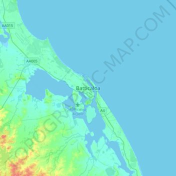
名称:Batticaloa地形图、海拔、地势。
平均海拔:5 米
最低海拔:-2 米
最高海拔:67 米
其他地形图
点击地图以查看其地形、其海拔和其地势。