
Broadstairs地形图
点击地图以显示海拔。
关于这张地图
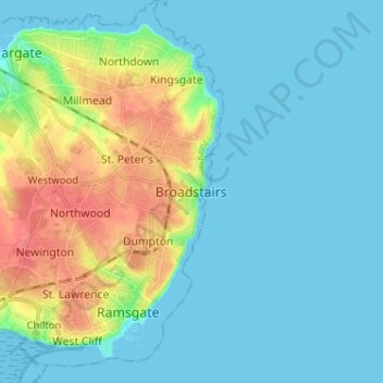
名称:Broadstairs地形图、海拔、地势。
地点:Broadstairs, Thanet, Kent, England, CT10 1BH, United Kingdom (51.31868 1.40079 51.39868 1.48079)
平均海拔:14 米
最低海拔:0 米
最高海拔:56 米
其他地形图
点击地图以查看其地形、其海拔和其地势。
Ramsgate
United Kingdom > England > Kent > Thanet
In 2017 Ramsgate was chosen as one of the first ten Heritage Action Zones (HAZ) by Historic England, with the aim of stimulating economic growth by taking advantage of Ramsgate's historic environment. Part of this project included a Historic Landscape Characterisation Study which assessed and mapped the…
平均海拔:25 米
Ramsgate
United Kingdom > England > Kent > Thanet
In 2017 Ramsgate was chosen as one of the first ten Heritage Action Zones (HAZ) by Historic England, with the aim of stimulating economic growth using Ramsgate's historic environment as a catalyst. Part of this project included a Historic Landscape Characterisation Study which assessed and mapped the patterns…
平均海拔:25 米