Rohanda地形图
点击地图以显示海拔。
关于这张地图
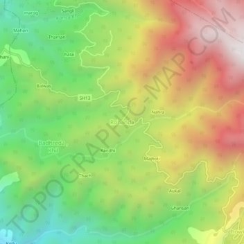
名称:Rohanda地形图、海拔、地势。
地点:Rohanda, Nihri, Mandi, Himachal Pradesh, 175031, India (31.44159 77.00745 31.48159 77.04745)
平均海拔:2,124 米
最低海拔:1,473 米
最高海拔:2,899 米

点击地图以显示海拔。
名称:Rohanda地形图、海拔、地势。
地点:Rohanda, Nihri, Mandi, Himachal Pradesh, 175031, India (31.44159 77.00745 31.48159 77.04745)
平均海拔:2,124 米
最低海拔:1,473 米
最高海拔:2,899 米