
Lavon地形图
点击地图以显示海拔。
关于这张地图
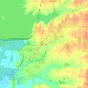
名称:Lavon地形图、海拔、地势。
地点:Lavon, Collin County, Texas, 75173, United States (32.98762 -96.47415 33.06762 -96.39415)
平均海拔:156 米
最低海拔:131 米
最高海拔:183 米
其他地形图
点击地图以查看其地形、其海拔和其地势。
Plano
United States > Texas > Collin County
At first, Plano's population grew slowly, reaching 1,304 in 1900 and 3,695 in 1960. By 1970, Plano began to feel some of the boom its neighbors had experienced after World War II. A series of public works projects and a change in taxes that removed the farming community from the town helped increase the…
平均海拔:196 米
Frisco
United States > Texas > Collin County
In 1902, a line of the St. Louis-San Francisco Railway was being built through the area, and periodic watering stops were needed along the route for the steam locomotives. The current settlement of Lebanon was on the Preston Ridge, and was too high in elevation, so the watering stop was placed about 4 miles (6…
平均海拔:201 米
Frisco
United States > Texas > Collin County
In 1902, a line of the St. Louis–San Francisco Railway ("the Frisco") was being built through the area, and periodic watering stops were needed along the route for the steam locomotives. The current settlement of Lebanon was on Preston Ridge and was too high in elevation, so the watering stop was placed…
平均海拔:201 米
Plano
United States > Texas > Collin County
At first, Plano's population grew slowly, reaching 1,304 in 1900 and 3,695 in 1960. By 1970, Plano began to feel some of the boom its neighbors had experienced after World War II. A series of public works projects and a change in taxes that removed the farming community from the town helped increase the…
平均海拔:196 米