
Pumpkin地形图
点击地图以显示海拔。
关于这张地图
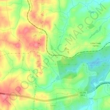
名称:Pumpkin地形图、海拔、地势。
地点:Pumpkin, Paulding County, Georgia, 30123, United States (33.90871 -84.91522 33.94871 -84.87522)
平均海拔:300 米
最低海拔:258 米
最高海拔:346 米
其他地形图
点击地图以查看其地形、其海拔和其地势。
Dallas
United States > Georgia > Paulding County
On April 4, 1977, near the site marker for the Battle of New Hope Church, the forced landing of Southern Airways Flight 242 occurred. The passenger jetliner, a McDonnell Douglas DC-9 with 81 passengers and 4 crew members, was flying from Northwest Alabama Regional Airport to Atlanta Municipal Airport. Upon…
平均海拔:307 米