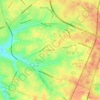
点击地图以显示海拔。
名称:Monticello地形图、海拔、地势。
地点:Monticello, Lexington, Fayette County, Kentucky, 40514, United States (37.97230 -84.57022 38.01230 -84.53022)
平均海拔:302 米
最低海拔:274 米
最高海拔:320 米
点击地图以查看其地形、其海拔和其地势。
United States > Kentucky > Fayette County > Lexington
平均海拔:305 米
平均海拔:292 米
平均海拔:290 米
平均海拔:273 米
平均海拔:287 米
平均海拔:307 米
平均海拔:309 米
平均海拔:299 米