
Mount Sefton地形图
点击地图以显示海拔。
关于这张地图
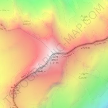
名称:Mount Sefton地形图、海拔、地势。
地点:Mount Sefton, Mackenzie District, Canterbury, New Zealand (-43.68251 170.04206 -43.68241 170.04216)
平均海拔:2,327 米
最低海拔:1,180 米
最高海拔:3,122 米
其他地形图
点击地图以查看其地形、其海拔和其地势。
Aoraki / Mount Cook National Park
New Zealand > Canterbury > Mackenzie District
Temperatures in Mount Cook Village range between extremes of −13 °C (9 °F) to 32 °C (90 °F), and typically fall just over 1 °C (34 °F) for every 200 metres (660 ft) of additional altitude.
平均海拔:1,386 米
Tasman Glacier
New Zealand > Canterbury > Mackenzie District
At 23.5 kilometres (14.6 mi) in length, Tasman Glacier is still New Zealand's longest glacier, despite shrinking considerably from the 1990s onwards. It is as much as 4 kilometres (2.5 mi) wide and 600 metres (2,000 ft) thick, and lies entirely within the borders of Aoraki / Mount Cook National Park. The…
平均海拔:1,884 米
Lake Tekapo
New Zealand > Canterbury > Mackenzie District
Lake Tekapo (Māori: Takapō) is the second-largest of three roughly parallel lakes running north–south along the northern edge of the Mackenzie Basin in the South Island of New Zealand (the others are Lake Pukaki and Lake Ōhau). It covers an area of 83 square kilometres (32 sq mi) and is at an altitude of…
平均海拔:1,025 米