
Virginia Beach地形图
点击地图以显示海拔。
Virginia Beach
According to the United States Census Bureau, the city has a total area of 497 square miles (1,290 km2), of which 249 square miles (640 km2) is land and 248 square miles (640 km2) (49.9%) is water. It is the largest city in Virginia by total area and third-largest city land area. The average elevation is 12 feet (3.7 m) above sea level. A major portion of the city drains to the Chesapeake Bay by way of the Lynnhaven River and its tributaries.
关于这张地图
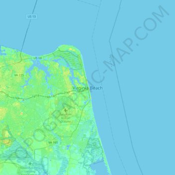
名称:Virginia Beach地形图、海拔、地势。
地点:Virginia Beach, Virginia, 23451, United States (36.69298 -76.13742 37.01298 -75.81742)
平均海拔:2 米
最低海拔:-12 米
最高海拔:17 米