
Mwanza地形图
点击地图以显示海拔。
Mwanza
Mwanza features a tropical savanna climate under the Köppen climate classification. Temperatures are relatively consistent throughout the course of the year, tempered by the city's altitude. Thus, the climate is not quite as hot as one might expect, given the city's location near the equator. Average temperatures in Mwanza is roughly 23.5 °C (74.3 °F) throughout the year. The city features a lengthy wet season which runs from October through May and a short pronounced dry season that covers the remaining four months. Mwanza receives on average roughly 1,050 millimetres (41 in) of precipitation annually.
关于这张地图
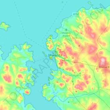
名称:Mwanza地形图、海拔、地势。
地点:Mwanza, Nyamagana, Mwanza Region, Lake Zone, 33214, Tanzania (-2.67969 32.74144 -2.35969 33.06144)
平均海拔:1,178 米
最低海拔:1,129 米
最高海拔:1,346 米
其他地形图
点击地图以查看其地形、其海拔和其地势。