
Patrick地形图
点击地图以显示海拔。
关于这张地图
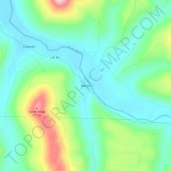
名称:Patrick地形图、海拔、地势。
地点:Patrick, Madison County, Arkansas, United States (35.82314 -93.90381 35.86314 -93.86381)
平均海拔:479 米
最低海拔:404 米
最高海拔:671 米
其他地形图
点击地图以查看其地形、其海拔和其地势。
Saint Paul
United States > Arkansas > Madison County
St. Paul is located in the Upper Boston Mountains ecoregion. The ecoregion is generally higher and moister than the Lower Boston Mountains; elevations vary from 1,900 to 2,800 feet (580 to 850 m). Potential natural vegetation is oak–hickory forest. Characteristically, the forests of the Upper Boston…
平均海拔:529 米