
Crescent地形图
点击地图以显示海拔。
关于这张地图
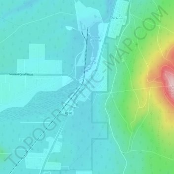
名称:Crescent地形图、海拔、地势。
地点:Crescent, Klamath County, Oregon, United States (43.44229 -121.71520 43.48229 -121.67520)
平均海拔:1,389 米
最低海拔:1,347 米
最高海拔:1,581 米
其他地形图
点击地图以查看其地形、其海拔和其地势。
Malin
United States > Oregon > Klamath County
Malin is at an elevation of 4,062 feet (1,238 m) in southern Klamath County near the Oregon–California border. It is along a spur of Oregon Route 39, southeast of Klamath Falls, east of Merrill, and northeast of Tulelake. Lava Beds National Monument is to the south, nearby in California. By highway, the city…
平均海拔:1,241 米
Merrill
United States > Oregon > Klamath County
Merrill is at an elevation of 4,071 feet (1,241 m) in southern Klamath County, near the Oregon–California border. It is along Oregon Route 39 southeast of Klamath Falls and northwest of Tulelake. Lower Klamath Lake and Tule Lake, both in California, are slightly south of Merrill. By highway, the city is 20…
平均海拔:1,241 米