
Snowshoe地形图
点击地图以显示海拔。
关于这张地图
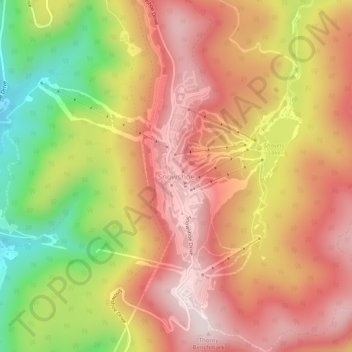
名称:Snowshoe地形图、海拔、地势。
平均海拔:1,270 米
最低海拔:964 米
最高海拔:1,476 米
其他地形图
点击地图以查看其地形、其海拔和其地势。
Cranberry Wilderness
United States > West Virginia > Pocahontas County
The wilderness is located in the Yew Mountains, which are part of the Allegheny Mountains. The highest point in the wilderness is along Black Mountain at 4,556 feet (1,389 m), although there is a slightly higher point at 4,603 feet (1,403 m) just outside the wilderness. The lowest elevation in the wilderness…
平均海拔:1,100 米
Monongahela National Forest
United States > West Virginia > Pocahontas County
In 1943 and 1944, as part of the West Virginia Maneuver Area, the U.S. Army used parts of the Monongahela National Forest as a practice artillery and mortar range and maneuver area before troops were sent to Europe to fight in World War II. Artillery and mortar shells shot into the area for practice are still…
平均海拔:655 米
Green Bank Telescope
United States > West Virginia > Pocahontas County
As an azimuth-elevation mounting telescope, the azimuth adjustments are driven by four trucks with four wheels each on a 210-foot (64 m) diameter rail. The 16 thirty-horsepower motors can change azimuth at the rate of up to 40 degrees per minute. Azimuth axis is also supported by a pintle bearing at the center…
平均海拔:822 米