
Abha地形图
点击地图以显示海拔。
Abha
Abha is located in the southern region of Asir at an elevation of about 2,270 metres (7,450 feet) above sea level. Abha lies on the western edge of Mount Al-Hijaz, near Jabal Sawda, the highest peak in Saudi Arabia. Treating the Asir Mountains as part of the Sarawat, the landscape is otherwise dominated by the Sarawat Mountains.
关于这张地图
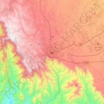
名称:Abha地形图、海拔、地势。
地点:Abha, 'Asir Province, 26442, Saudi Arabia (18.05643 42.34436 18.37643 42.66436)
平均海拔:1,994 米
最低海拔:722 米
最高海拔:2,991 米