
Fruitland地形图
点击地图以显示海拔。
关于这张地图
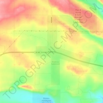
名称:Fruitland地形图、海拔、地势。
地点:Fruitland, Duchesne County, Utah, 84027, United States (40.19273 -110.85961 40.23273 -110.81961)
平均海拔:2,028 米
最低海拔:1,971 米
最高海拔:2,075 米
其他地形图
点击地图以查看其地形、其海拔和其地势。
Roosevelt
United States > Utah > Duchesne County
Roosevelt is situated on U.S. Route 40 in the northeast corner of the state, south of the Uinta Mountains, at an elevation of 5,250 feet (1,600 m). The town was incorporated at a mass meeting of 44 citizens on 21 February 1913. From 1906 to 1914 Roosevelt was in Wasatch County, but in 1914 Duchesne County was…
平均海拔:1,553 米