
Broad Haven地形图
点击地图以显示海拔。
关于这张地图
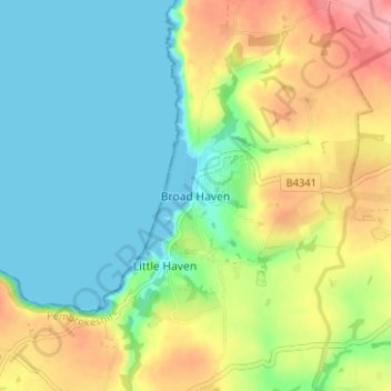
名称:Broad Haven地形图、海拔、地势。
地点:Broad Haven, Pembrokeshire, Wales, SA62 3JR, United Kingdom (51.76037 -5.12238 51.80037 -5.08238)
平均海拔:41 米
最低海拔:0 米
最高海拔:114 米
其他地形图
点击地图以查看其地形、其海拔和其地势。
Milford Haven
United Kingdom > Wales > Pembrokeshire
One of the earliest notable figures from the Milford Haven area is Howell Davis, a pirate born in 1680. He was shot dead in 1719 on the Portuguese island of Príncipe. Other famous residents connected as seafarers include Isaac Davis, a former seaman who was engaged in the fur trade between the Pacific…
平均海拔:36 米
Preseli Mountains
United Kingdom > Wales > Pembrokeshire > Puncheston
Samuel Lewis's A Topographical Dictionary of Wales published in 1833 said of Maenclochog parish.
平均海拔:217 米
Milford Haven
United Kingdom > Wales > Pembrokeshire
One of the earliest notable figures from the Milford Haven area is Howell Davis, a pirate born in 1680. He was shot dead in 1719 on the Portuguese island of Príncipe. Other famous residents connected as seafarers include Isaac Davis, a former seaman who was engaged in the fur trade between the Pacific…
平均海拔:36 米
Puncheston
United Kingdom > Wales > Pembrokeshire
A map of 1578 shows the parish as Castle Male, presumably a phonetic spelling of the Welsh name by the English mapmaker. Lewis's Topographical Dictionary of 1844 gives 326 inhabitants (the 1849 edition gives 255) for the parish, which includes the village and a number of outlying residences and farms. Lewis…
平均海拔:165 米