
Gikomba地形图
点击地图以显示海拔。
关于这张地图
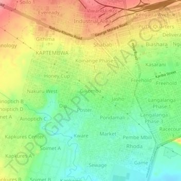
名称:Gikomba地形图、海拔、地势。
地点:Gikomba, Nakuru, Kenya (-0.32134 36.03472 -0.28134 36.07472)
平均海拔:1,817 米
最低海拔:1,769 米
最高海拔:1,874 米
其他地形图
点击地图以查看其地形、其海拔和其地势。
Nakuru
Kenya > Nakuru > Nakuru West
The city’s growth has led to the development of residential neighborhoods catering to diverse demographics. Milimani is an affluent area known for its quiet, secure environment, while Section 58 and Kiamunyi offer modern homes and spacious plots suitable for families. More affordable areas like Langalanga…
平均海拔:1,893 米
Lake Nakuru
Kenya > Nakuru > Nakuru West > Barut ward
Lake Nakuru is one of the Rift Valley lakes, located at an elevation of 1,754 m (5,755 ft) above sea level. It lies to the south of Nakuru, in the rift valley of Kenya and is protected by Lake Nakuru National Park.
平均海拔:1,813 米
Lake Nakuru
Lake Nakuru is one of the Rift Valley soda lakes at an elevation of 1,754 m (5,755 ft) above sea level. It lies to the south of Nakuru, in the rift valley of Kenya and is protected by Lake Nakuru National Park.
平均海拔:1,807 米