
Stave Hill地形图
点击地图以显示海拔。
关于这张地图
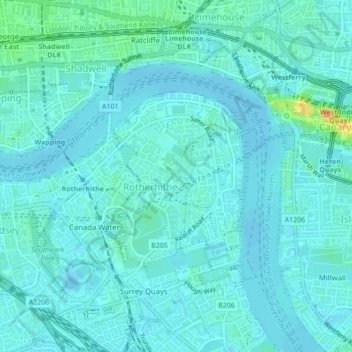
名称:Stave Hill地形图、海拔、地势。
平均海拔:6 米
最低海拔:-3 米
最高海拔:39 米
其他地形图
点击地图以查看其地形、其海拔和其地势。
Norwood Grove
United Kingdom > England > Greater London
After Anderson died, ownership passed to the Nettlefold family and subsequently to Frederick Nettlefold the brother of Joseph Nettlefold and a member of the family that founded the Nettlefolds Ltd. engineering firm which later became GKN. Nettlefold is commemorated, as a result of his charitable works, by a…
平均海拔:58 米