
Jefferson地形图
点击地图以显示海拔。
关于这张地图
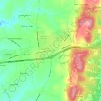
名称:Jefferson地形图、海拔、地势。
地点:Jefferson, Frederick County, Maryland, 21755, United States (39.34207 -77.55210 39.38207 -77.51210)
平均海拔:173 米
最低海拔:103 米
最高海拔:271 米
其他地形图
点击地图以查看其地形、其海拔和其地势。
Braddock Heights
United States > Maryland > Frederick County > Braddock Heights
Braddock Heights is located at an elevation of 950 feet (290 m) atop Braddock Mountain (as Catoctin Mountain is locally known) near the pass at Braddock Springs, so named after British General Edward Braddock and Lt. Colonel George Washington's use of the mountain pass on their way to Fort Duquesne during the…
平均海拔:179 米