点击地图以显示海拔。
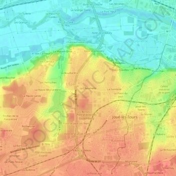
名称:La Chaumette地形图、海拔、地势。
地点:La Chaumette, Joué-lès-Tours, Tours, Indre-et-Loire, Centre-Val de Loire, France métropolitaine, 37300, France (47.33759 0.62992 47.37759 0.66992)
平均海拔:72 米
最低海拔:41 米
最高海拔:99 米
点击地图以查看其地形、其海拔和其地势。
France > Centre-Val de Loire > Indre-et-Loire > Joué-lès-Tours > La Petite Carte
平均海拔:85 米