点击地图以显示海拔。
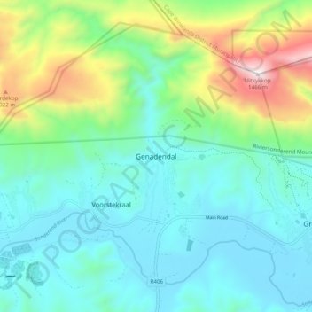
名称:Genadendal地形图、海拔、地势。
地点:Genadendal, Theewaterskloof Local Municipality, Western Cape, 7234, South Africa (-34.07344 19.51837 -33.99344 19.59837)
平均海拔:498 米
最低海拔:197 米
最高海拔:1,443 米
点击地图以查看其地形、其海拔和其地势。
South Africa > Western Cape > Theewaterskloof Local Municipality
平均海拔:434 米