
Bukoba地形图
点击地图以显示海拔。
Bukoba
Bukoba has an upland tropical monsoon climate (Köppen Amb, because every month has a normal mean temperature of between 18 °C and 22 °C) although it is milder than most climates with that classification due to its altitude. It can sometimes get cool especially in the evenings during the two rainy seasons, but never as cold as the winter season in Europe.
关于这张地图
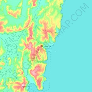
名称:Bukoba地形图、海拔、地势。
地点:Bukoba, Kagera, Lake Zone, Tanzania (-1.49115 31.65256 -1.17115 31.97256)
平均海拔:1,177 米
最低海拔:1,128 米
最高海拔:1,405 米
其他地形图
点击地图以查看其地形、其海拔和其地势。