Shannondale地形图
点击地图以显示海拔。
关于这张地图
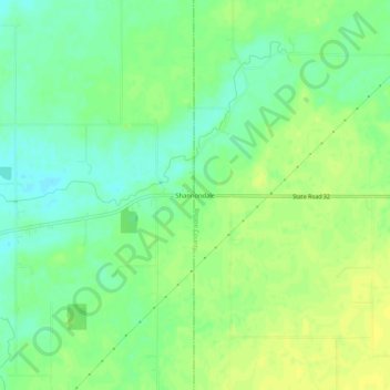
名称:Shannondale地形图、海拔、地势。
地点:Shannondale, Boone County, Indiana, United States (40.03476 -86.71556 40.07476 -86.67556)
平均海拔:265 米
最低海拔:255 米
最高海拔:273 米
其他地形图
点击地图以查看其地形、其海拔和其地势。

点击地图以显示海拔。
名称:Shannondale地形图、海拔、地势。
地点:Shannondale, Boone County, Indiana, United States (40.03476 -86.71556 40.07476 -86.67556)
平均海拔:265 米
最低海拔:255 米
最高海拔:273 米
点击地图以查看其地形、其海拔和其地势。