Travanet地形图
点击地图以显示海拔。
关于这张地图
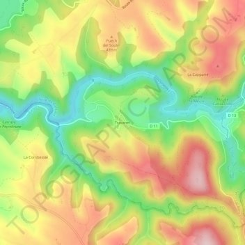
名称:Travanet地形图、海拔、地势。
平均海拔:381 米
最低海拔:235 米
最高海拔:527 米
其他地形图
点击地图以查看其地形、其海拔和其地势。
Ronel
France > Occitanie > Tarn > Terre-de-Bancalié
L'altitude de la commune varie entre 235 et 370 mètres.
平均海拔:290 米

点击地图以显示海拔。
名称:Travanet地形图、海拔、地势。
平均海拔:381 米
最低海拔:235 米
最高海拔:527 米
点击地图以查看其地形、其海拔和其地势。
France > Occitanie > Tarn > Terre-de-Bancalié
L'altitude de la commune varie entre 235 et 370 mètres.
平均海拔:290 米