
Mulanay地形图
点击地图以显示海拔。
关于这张地图
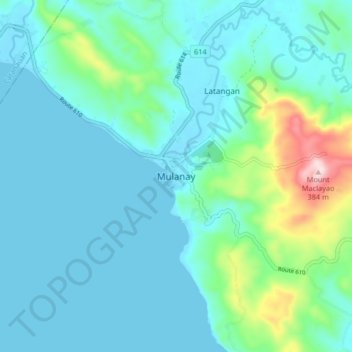
名称:Mulanay地形图、海拔、地势。
地点:Mulanay, Quezon, Calabarzon, 4312, Philippines (13.48180 122.36402 13.56180 122.44402)
平均海拔:61 米
最低海拔:0 米
最高海拔:372 米
其他地形图
点击地图以查看其地形、其海拔和其地势。
Sariaya
Sariaya is situated on a flat land except for a portion on the north occupying a part of the foot of Mount Banahaw. The municipality has the highest point of elevation on 3,800 feet (1,200 m) above sea level at Barangays Concepcion Banahaw and Sampaloc Bogon.
平均海拔:117 米
Sariaya
Sariaya is situated on a flat land except for a portion on the north occupying a part of the foot of Mount Banahaw. The municipality has the highest point of elevation on 3,800 feet above sea level at Barangays Concepcion Banahaw and Sampaloc Bogon.
平均海拔:117 米
Sariaya
Sariaya is situated on a flat land except for a portion on the north occupying a part of the foot of Mount Banahaw. The municipality has the highest point of elevation on 3,800 feet (1,200 m) above sea level at Barangays Concepcion Banahaw and Sampaloc Bogon.
平均海拔:117 米
Sariaya
Sariaya is situated on a flat land except for a portion on the north occupying a part of the foot of Mount Banahaw. The municipality has the highest point of elevation on 3,800 feet (1,200 m) above sea level at Barangays Concepcion Banahaw and Sampaloc Bogon.
平均海拔:117 米
Sariaya
Sariaya is situated on a flat land except for a portion on the north occupying a part of the foot of Mount Banahaw. The municipality has the highest point of elevation on 3,800 feet above sea level at Barangays Concepcion Banahaw and Sampaloc Bogon.
平均海拔:117 米