Pontevedra地形图
点击地图以显示海拔。
关于这张地图
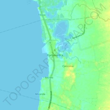
名称:Pontevedra地形图、海拔、地势。
地点:Pontevedra, Negros Occidental, Western Visayas, Philippines (10.32788 122.83039 10.40788 122.91039)
平均海拔:5 米
最低海拔:-1 米
最高海拔:21 米

点击地图以显示海拔。
名称:Pontevedra地形图、海拔、地势。
地点:Pontevedra, Negros Occidental, Western Visayas, Philippines (10.32788 122.83039 10.40788 122.91039)
平均海拔:5 米
最低海拔:-1 米
最高海拔:21 米