
Vyas (Damauli)地形图
点击地图以显示海拔。
关于这张地图
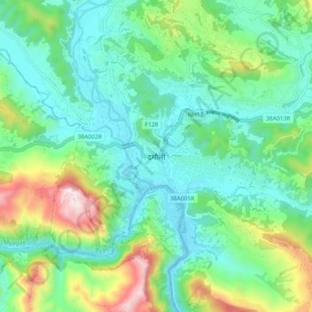
名称:Vyas (Damauli)地形图、海拔、地势。
地点:Vyas (Damauli), Byas, Tanahun, Gandaki Province, Nepal (27.93706 84.22862 28.01706 84.30862)
平均海拔:501 米
最低海拔:294 米
最高海拔:1,079 米
其他地形图
点击地图以查看其地形、其海拔和其地势。
Bandipur
Nepal > Gandaki Province > Tanahun
Bandipur is located at 27.56 N, 84.25 E and an elevation of 1030m on a mountain saddle (Mahabharat range) approximately 700m above the Marsyangdi River Valley, 143 km to the west of Kathmandu and 80 km to the east of Pokhara. Since 1998 it is connected by an 8 km access road from Dumre (Prithvi Highway). Until…
平均海拔:719 米