
Brooks Range地形图
点击地图以显示海拔。
关于这张地图
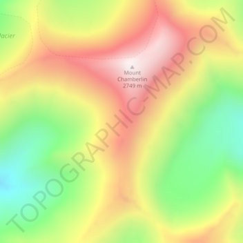
名称:Brooks Range地形图、海拔、地势。
地点:Brooks Range, North Slope Borough, Alaska, United States (69.27135 -144.91375 69.27145 -144.91365)
平均海拔:2,115 米
最低海拔:1,578 米
最高海拔:2,720 米
其他地形图
点击地图以查看其地形、其海拔和其地势。
Utqiaġvik
United States > Alaska > North Slope Borough
Despite the extreme northern location, temperatures at Utqiagvik are moderated by the surrounding topography. The Arctic Ocean is on three sides, and flat tundra stretches some 200 mi (320 km) to the south. No wind barriers or protected valleys exist where dense cold air can settle or form temperature…
平均海拔:4 米
Toolik Lake
United States > Alaska > North Slope Borough
Tussock tundra dominates the terrain surrounding the lake. Other plant communities in the area include wet sedge tundra, as well drier heath tundra found at higher elevations. Low growing shrubs are abundant, including birches and willows. Trees are not present. Since surveys began, there has been a 19 percent…
平均海拔:731 米
Utqiaġvik
United States > Alaska > North Slope Borough
Despite the extreme northern location, temperatures at Utqiagvik are moderated by the surrounding topography. The Arctic Ocean is on three sides, and flat tundra stretches some 200 mi (320 km) to the south. No wind barriers or protected valleys exist where dense cold air can settle or form temperature…
平均海拔:4 米