
Malvern地形图
点击地图以显示海拔。
Malvern
Malvern lies in the Lower Severn/Avon plain affording it a degree of shelter caused by virtue of its nestling in between the Cotswold hills to the east, the Welsh Hills and Mountains to the west, and Birmingham plateau to the north. Although as with all the British Isles it has a maritime climate, the local topography means summer warmth can become emphasised by a slight foehn effect off the surrounding hills. The record maximum stands at 35.8c(96.4f) set in August 1990. Typically 17.3 days of the year will reach 25.1c(77.2f) or higher and the annual warmest day should reach 29.8c(85.6f) according to the 1971–00 observing period.
关于这张地图
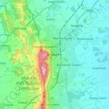
名称:Malvern地形图、海拔、地势。
平均海拔:95 米
最低海拔:19 米
最高海拔:423 米
其他地形图
点击地图以查看其地形、其海拔和其地势。
Knighton on Teme
United Kingdom > England > Worcestershire > Malvern Hills > Knighton on Teme
平均海拔:82 米
West Malvern
United Kingdom > England > Worcestershire > Malvern Hills
West Malvern is a village and a civil parish on the west side of the north part of the Malvern Hills, on the western edge of Worcestershire, England. It has become effectively a suburb of Malvern and part of an urban area often called The Malverns, locally administered by Malvern Hills District Council and its…
平均海拔:198 米